GPS Navigation Route Finder
- 4.5
- Rating
- 10.00M
- Installs
- Free
- Price
 Analysis by App-foxy
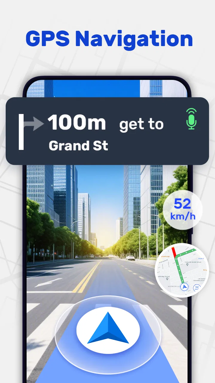
When I try a navigation app, I care less about how many buttons it has and more about whether it helps me make the right turn without turning a simple drive into a second job. GPS Navigation Route Finder is built around that practical need. Its main strength is the combination of route planning, turn-by-turn guidance, offline maps, and a live street-view element, all inside a free Maps & Navigation app from Travel Tools Studio.
I found the offline map capability especially important. A route can look perfect while I am connected to Wi-Fi, yet become much less useful when mobile coverage weakens on a rural road, in a tunnel, or during a trip where I am trying to limit data use. Here, offline access changes the role of the app: it is not only a route finder for ordinary commutes, but also a backup I can prepare before leaving.
The app is available to everyone, runs on Android 6.0 and newer, and its current version is 2.11.5. It is free to install, although in-app purchases range from $4.99 to $29.99 per item. With an average rating of 4.5 from around 29 thousand ratings and more than 10 million installs, it has clearly attracted a sizeable audience. Those figures do not replace personal testing, but they do suggest that the basic navigation idea works for many different driving habits.
You May Also Like

 AccuWeather: Weather Radar
AccuWeather Review: A Quick, Clear Forecast for Everyday Decisions
For everyday plans, the best forecast is the one you can understand quickly. AccuWeather makes rain timing, radar, and local conditions easy to act on, with a few trade-offs.

 Hill Climb Racing
Why Hill Climb Racing Still Turns Crashes Into One More Run
A tiny car, a bumpy hill and one more upgrade: Hill Climb Racing keeps resurfacing because its simple chaos makes every near-miss feel personal.

 AliExpress - Shopping App
AliExpress Makes Global Shopping Feel Personal, but Shoppers Bear the Risk
AliExpress turns a global marketplace into a pocket-sized discovery engine. Its reach is useful, its shopping loop compelling, and its trade-offs easy to miss.

 Lords Mobile: Kingdom Wars
Lords Mobile Is a Kingdom-Building Routine, Not a Quick Match
A case-by-case verdict on the building, battles, device demands, and social commitments that make Lords Mobile rewarding for some players and exhausting for others.

 PDF Scanner app - TapScanner
TapScanner Makes Paperwork Easier to Capture, Check, and Share
TapScanner makes scanning with a phone feel less like a rescue operation and more like a dependable step in getting work done. Its capture tools are useful, though not flawless.

 Block Blast!
 Shows How Much a Puzzle Game Can Leave Out
A quiet grid game shows why puzzle players increasingly value instant clarity, repeatable skill and low-pressure play—and where the genre still needs to catch up.
More From Our News Desk
View All News


Offline navigation is the capability that matters most
I find offline navigation most valuable when it changes how I prepare, not just what I can do after the signal drops. The useful question is whether the route and map are ready before I leave, so I can avoid troubleshooting on the roadside. That preparation also clarifies where this app earns a place beside more familiar navigation tools.
Why an offline route can be more useful than a clever online one
The most meaningful feature here is not simply seeing a line between two places. It is being able to prepare that route before the drive and still have useful guidance when the connection is unreliable. In everyday use, that means I can think about the trip while connected, then drive with less worry about whether the next instruction will load at the exact moment I need it.
This is particularly helpful for long drives that cross areas with patchy reception. It is also useful when I am travelling internationally and do not want navigation to depend on continuous mobile data. I would still check the route before starting, because offline preparation is only valuable if I actually remember to do it. The app cannot remove the need for sensible planning, but it can reduce one common source of stress.
There is a subtle difference between an offline map and an offline driving experience. A downloaded map may let me inspect roads, while turn-by-turn guidance needs the route to be calculated in a way the app can use during the journey. My practical advice is to set the destination, review the proposed path, and keep the app open long enough to confirm that the route is ready before driving away. That small routine is more dependable than assuming every map screen automatically means full offline guidance.
Preparing a route before leaving
I would use GPS Navigation Route Finder in three stages. First, I would enter the destination while I have a stable connection. Second, I would look over the route rather than accepting it blindly. Third, I would make sure the map area needed for the trip is available before starting the car. This workflow is more valuable than simply opening the app after losing reception, because a navigation tool cannot be expected to build a new route if the information it needs is unavailable.
Reviewing the route also helps me notice practical issues that a spoken instruction may hide. A route can be technically short but inconvenient if it includes unfamiliar turns, narrow local roads, or a complicated approach to the final destination. I like having the chance to inspect the path first, especially when I am driving somewhere for the first time.
The live street-view function adds another layer before departure. I can use visual context to understand what an area may look like around an important turn or near a destination. I would not treat that view as a guarantee that the scene will look identical when I arrive, since roads and surroundings change, but it can make an unfamiliar approach easier to recognise.
Turn-by-turn guidance during the drive
Once I am moving, the value of the app becomes much more immediate. Turn-by-turn navigation is most useful when it gives me enough warning to choose a lane or slow down calmly, rather than presenting an instruction at the last possible moment. I still keep my attention on the road and use the guidance as support, not as permission to stop thinking.
One habit I recommend is checking the next few decisions while parked before setting off. If the route contains several turns close together, knowing that sequence in advance makes the spoken instructions easier to follow. It also gives me a chance to notice whether the route passes through a busy area where I would prefer to pause and reassess rather than make a rushed manoeuvre.
The app is best viewed as a driver’s companion, not a replacement for road signs. Local signs, temporary closures, construction, and changing traffic conditions can make the real road different from the planned route. If the app and the road disagree, I would follow legal signs and safe driving practice first, then recalculate when it is safe to do so.
A realistic everyday journey
Imagine I am driving from a city to a rented cottage outside the usual coverage area. At home, I can enter the address, examine the route, and prepare the relevant map area. Before leaving, I can use the visual view to understand the final approach, which may be more useful than relying on a street name that is difficult to spot from the road.
During the first part of the trip, online guidance can help me stay aware of the route. Later, if the signal becomes weak, the offline preparation becomes the safety net. I am not suddenly trying to search for the destination from scratch. I already made the important decisions while connected, so the app’s role is more manageable: keep me oriented and tell me when the next planned turn is coming.
That scenario shows the real effect of the offline capability. It does not make every journey effortless, and it does not guarantee that a route will remain ideal after conditions change. What it does is move some of the uncertainty from the middle of the drive to the planning stage, when I have time and attention available.
Using street view as a planning tool
The live street-view option is more useful to me as a preparation aid than as something I would constantly watch while driving. Before a trip, I can use it to recognise the surroundings near a destination, compare the map position with the visible road layout, and reduce the chance of missing an entrance because the address pin is technically correct but visually unhelpful.
This can matter at places such as large buildings, unfamiliar neighbourhoods, or destinations with more than one possible access road. I would still avoid depending on a single visual clue. A sign may be hidden, a vehicle may block the view, or the imagery may not reflect current conditions. Used sensibly, though, street view turns the final part of a route from a purely abstract map exercise into something I can mentally picture.
Where the app fits better than the usual alternatives
I judge a navigation app by the trips it handles comfortably, rather than by whether it replaces every alternative. GPS Navigation Route Finder has a particular appeal for journeys where advance planning and access without a steady connection matter more than constantly refreshed traffic advice. That distinction makes the comparison with everyday online navigators more practical.
Compared with relying only on a standard online navigator
Popular online navigation services are often excellent when a strong connection is available and when live traffic information is central to the journey. They may be the better choice for a daily urban commute where conditions change quickly and the best route depends on current congestion. GPS Navigation Route Finder makes more sense when I value route preparation and offline access as much as live guidance.
The trade-off is straightforward. An offline route can remain available when connectivity is weak, but it may not respond to changing conditions in the same way as a continuously connected service. For a familiar city drive at a busy hour, I would compare the route with a service known for live traffic updates. For a remote trip, a holiday drive, or a journey where data access is uncertain, I would give this app a stronger look.
Compared with a dedicated offline map app
A dedicated offline map application may offer deeper map-management controls or a more specialised experience for people who spend a lot of time travelling without a connection. GPS Navigation Route Finder is more approachable for someone who wants the main driving tasks in one place: find a route, follow directions, inspect the surroundings, and prepare for offline use.
That simplicity can be an advantage, but it also means I would not choose it automatically for every kind of navigation. Hikers, cyclists, professional drivers with specialised routing needs, or people who require detailed travel planning may be better served by an app designed specifically for those activities. This one is aimed more naturally at ordinary road journeys.
Compared with the phone’s built-in navigation option
The built-in option on a phone has an obvious convenience advantage: it is already familiar, and many people have saved places, contacts, and habits connected to it. Switching to another app only makes sense if GPS Navigation Route Finder’s offline preparation and visual route checking solve a problem I actually have.
For me, that problem would be travelling beyond dependable coverage or wanting a separate navigation tool that I can prepare specifically for a trip. If I only drive between places I know well in a connected city, the change may not be worthwhile. The app earns its place when its central capability matches the journey rather than simply adding another icon to my screen.
Small workflow choices that improve the experience
I would keep the destination search as precise as possible, especially for large venues or addresses with several entrances. Selecting a nearby road or recognisable point may be more practical than trusting a broad place name. After the route is created, I would inspect the final approach and not just the total distance or estimated arrival.
I would also prepare an offline route before entering a low-signal area, then keep a backup understanding of the general direction. A quick look at major roads and the final turn is useful if I need to make a safe stop and reassess. This is one of the less obvious benefits of offline planning: it encourages me to think about the trip before I am under pressure.
Finally, I would avoid testing a newly prepared route for the first time while already driving. The best moment to learn where the map controls, route view, and street-view tools are located is at home or while parked. That is basic advice, but it makes a noticeable difference with any navigation app that combines several views.
Trade-offs, limitations, and the people most likely to enjoy it
I would choose this app for planned driving where offline access and a clearer sense of the destination are useful, while staying realistic about what route guidance can handle. Its value depends on preparing ahead and matching the tool to the trip, rather than expecting one navigator to suit every driver. With that in mind, the trade-offs help show who is most likely to enjoy using it.
What may cause friction
The free price is appealing, but the presence of in-app purchases between $4.99 and $29.99 per item means I would check which parts of the experience are included before depending on it for an important trip. A free download does not automatically mean every useful option is available without an extra purchase, so I would explore the app while connected and make sure the workflow I need is ready in advance.
The offline capability also requires discipline. Maps do not help if I forget to prepare the area, choose the wrong destination, or assume that an old route reflects current road conditions. Offline use is a protection against connection problems, not a substitute for updating plans when a road is closed or a journey changes unexpectedly.
There is another practical limitation: navigation instructions can simplify complicated places. Multi-lane junctions, private entrances, roundabouts, and large car parks often require visual judgement that no short instruction can fully replace. The street-view tool can help with preparation, but I would still slow down, read signs, and avoid making a sudden turn simply because the voice prompt says so.
People who want constantly refreshed traffic intelligence may find a more connected, traffic-focused alternative more suitable. Likewise, drivers who need commercial vehicle restrictions, highly specialised route profiles, or detailed activity-specific maps should investigate tools built around those requirements instead of expecting a general driving app to cover them.
Who gains the most from it
I think the strongest audience is the occasional or regular driver who wants a straightforward navigation tool with a dependable preparation routine. It suits holiday travellers, people visiting unfamiliar towns, drivers crossing rural areas, and anyone who prefers not to make continuous data access the foundation of a trip.
It is also a good fit for someone who likes to preview the destination rather than arrive and start searching for the correct entrance. The combination of route guidance and visual checking can reduce uncertainty at the end of a journey, where a technically correct route may still leave a driver wondering which driveway or side road to use.
New drivers may appreciate the ability to review the route while parked, although I would not encourage anyone to follow directions mechanically. The app can support confidence, but safe navigation still depends on reading the road, anticipating turns, and accepting a missed turn rather than attempting an unsafe correction.
I would be less enthusiastic about recommending it to a person whose main need is live congestion avoidance in a dense city. In that case, the best tool is usually the one with the strongest current traffic picture and the most familiar local data. I would also hesitate for users who need navigation beyond ordinary car travel, because the app’s central value is clearly tied to driving routes.
Device support and day-to-day expectations
Support for Android 6.0 and newer makes the app accessible to people using older Android phones rather than only recent devices. That is useful for a spare phone kept in a car or for someone who does not upgrade frequently. Still, I would test the complete route workflow on the actual device before a long journey, particularly if the phone is older or has limited free storage for map material.
The app is rated for everyone, which fits its general-purpose navigation role. That does not mean every driving situation is simple, but it does make the product easy to consider for a household where different people may use the same phone or account. Travel Tools Studio has kept the concept broad enough for ordinary errands as well as longer trips.
My recommendation after using the route-first approach
GPS Navigation Route Finder is most convincing when I treat it as a preparation-first navigator. Its offline maps are not merely a backup label; they can change how I organise a trip, moving route decisions to a calmer moment before departure. The turn-by-turn guidance then becomes more useful because I already understand the general path, while street view helps me approach unfamiliar destinations with a clearer picture.
I would not replace every navigation service with it. Connected alternatives can be preferable for live traffic, and specialist apps can be better for specialised travel. I would also verify the route before leaving, check what is included beyond the free installation, and continue to follow road signs and safe driving practices.
For the right driver, though, the app offers a sensible balance: no purchase is required to get started, the age rating is broad, and the core experience focuses on getting from one place to another without making connectivity the only thing holding the route together. If your biggest navigation worry is losing access halfway through a journey, this is the capability worth trying first.
My final view is positive but specific. I recommend it to people who regularly plan trips outside dependable coverage, want to preview the approach to an unfamiliar destination, or prefer having a prepared route available before they set off. If your driving is almost entirely local and traffic changes are your top concern, another option may serve you better. For planned road travel where offline confidence matters, this app has a clear and useful reason to be on my phone.
FAQs for GPS Navigation Route Finder
01What is GPS Navigation Route Finder and what can I use it for?
GPS Navigation Route Finder is a mobile navigation application designed to help you plan routes and find your way by car, motorcycle, bicycle, or on foot. It can provide turn-by-turn directions, display your current location on a map, and help you search for destinations such as addresses, businesses, fuel stations, restaurants, and other points of interest, depending on the features available in your version.
02Does GPS Navigation Route Finder work without an internet connection?
The app may require an internet connection to search for new destinations, load map information, calculate routes, and receive updated traffic or road data. Some versions may support offline maps or previously loaded routes, but this depends on the application’s specific features and regional coverage. Before traveling to an area with poor reception, test the route and check whether offline navigation is available.
03How accurate are the routes and GPS directions provided by the app?
GPS Navigation Route Finder generally relies on your device’s GPS sensor and available map data to determine your position and suggest directions. Accuracy can be affected by tall buildings, tunnels, weather, weak satellite signals, outdated maps, or incorrect location permissions. Always compare the suggested route with road signs and local regulations, especially when driving in unfamiliar areas.
04Does the app provide live traffic information and alternative routes?
Traffic features can vary according to the app version, location, and available data sources. In supported areas, GPS Navigation Route Finder may show congestion, road delays, estimated travel times, or alternative routes. However, traffic information should not be treated as guaranteed or perfectly real time. Road conditions can change quickly, so review the route before starting and avoid interacting with the phone while driving.
05Is GPS Navigation Route Finder free to download, and are there advertisements or in-app purchases?
The application may be available as a free download, but the exact pricing model can depend on the platform and version. Free editions may include advertisements, optional premium tools, map downloads, voice guidance, or other in-app purchases. Check the Google Play Store or Apple App Store listing before installing to review permissions, subscription details, supported devices, and any costs that may apply.
Pros
- Clear turn-by-turn directions for driving and everyday trips.
- Useful route planning helps compare travel options before starting.
- GPS tracking makes it easier to monitor your current location.
- Search tools help find nearby places and destinations quickly.
- Practical for discovering unfamiliar roads and navigating new areas.
Cons
- Accurate navigation depends heavily on a stable GPS signal.
- Using GPS continuously can drain the phone battery quickly.
- Directions may become outdated when roads change unexpectedly.
- The app may use significant mobile data during longer journeys.
- Small screens can make map details difficult to read while driving.

GPS Navigation Route Finder
Gallery